Virtual Merri-bek
On this page:
By 2036, Merri-bek's population is expected to increase to 228,807. A key priority in our Council Plan 2017-21 is to enhance Merri-bek's liveability, affordability and sustainability by guiding growth and excellence in urban design and development.
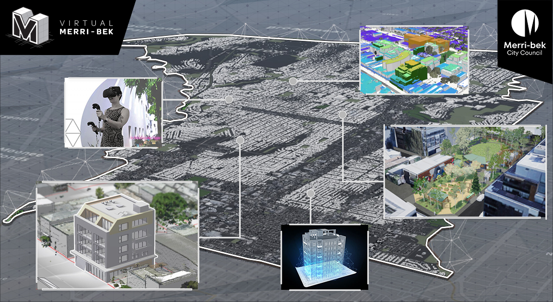
The Virtual Merri-bek project (formerly Virtual Moreland) is aimed at achieving this priority, by leveraging 3D GIS, 3D modelling and 3D visualisation in combination with emerging technologies such as virtual and augmented reality.
The goal of the project is to improve our decision-making process, improve design outcomes and improve community understanding of new developments and projects within the municipality.
The project began in December 2017 in partnership with KASA, Lost in the Machine and AAM. Initial funding was provided by the Australian Governments Smart Cities and Suburbs Program.
Virtual Merri-bek remains one of the first of it's kind in Australia, putting Merri-bek at the forefront of using emerging 3D, VR and AR technologies for planning and consultation purposes.
Project tools, data and outcomes
-
Council has partnered with geospatial experts AAM to capture and deliver a detailed 3D base model of Merri-bek City Council.
This base model is comprised of textured LOD2 3D models within and surrounding the main activity centres, LOD1 3D models outside of the main activity centres and a detailed 3D digital terrain model. Combined, this data gives Council an accurate 3D Digitial Twin model to build upon in the coming years, and to use with our 3D GIS, VR and AR platforms.

-
Virtual Merri-bek 3D (VM3D) is Council’s 3D digital twin platform.
What is a 3D digital twin? A 3D digital twin is an immersive 3D virtual copy of a real world object or place that looks and behaves like its real world counterpart.
VM3D brings together Council's 3D maps, 3D models, and spatial data into an interactive online environment. It supports statutory planning, strategic planning, urban design, open space and community engagement by making Council’s 3D datasets and 3D models of applicable proposed developments accessible for Council officers, stakeholders, and the community*.

-
Council partnered with Virtual Reality experts KASA to develop Virtual Merri-bek VR (Virtual reality). This is a VR tool that can be used for planning, and by the community.
This VR tool gives users the ability to view large proposed developments within Merri-bek in context. It does this by placing the proposed developments inside a detailed, 1:1 scale computer generated 3D recreation of Merri-bek.
Additional tools also allow users to take accurate 3D measurements, view zoning information, and design their own virtual spaces inside Merri-bek such as parks and public spaces.
You can book in a session to use our VR tools by emailing our Virtual Merri-bek Officer at virtual_moreland@moreland.vic.gov.au

-
By utilising the same data and technology behind our Virtual Merri-bek VR platform, we are able to produce in-house 3D renders and visualisations for new council projects.
Some of the projects which have utilised these services include:
- Park Close To Home
- Key Urban Design projects
-
NOTE: The virtual Merri-bek AR app has been decomissioned as of June 30th, 2021.
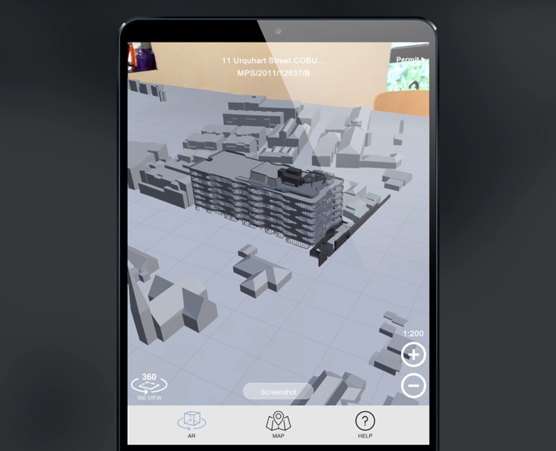
Moreland City Council partnered with XR (extended reality) experts Lost In The Machine to develop the My Virtual Merri-bek iOS and Android App, for the council and community.
Through the use augmented reality, the My Virtual Merri-bek app aims to bring visual transparency to planning applications within Merri-bek. Anyone with a compatible smart phone can retrieve a 3d model of select planning applications and view them in AR – on location or on a tabletop. Where previously there would be concept sketches, now a user can view potential visual impacts at scale, i.e. overshadowing or overlooking views into another property.
The My Virtual Merri-bek app also provides the community with a better way of gathering vital information about advertised planning applications using a variety of user friendly and intuitive search tools. Users can searching by address, keywords, application number or by simply viewing all advertised planning applications as pinned locations on a map of Merri-bek.
To view walkthrough videos on how the app functions
The My Virtual Merri-bek app features two AR modes:
Indoor AR mode allows users to view a miniature version of proposed developments in context using a simple printable AR marker on a table top. A 360 mode also allows the user to simulate a 1:1 scale 360 view from any position such as rooftops, balconies and ground level.
Outdoor AR mode is a location based mode which overlays a 3D model of the proposed development at the site of the application allowing the user to visualise the proposed development at 1:1 scale from any angle.
3D model submission guidelines (for developers & architects)
A 3D digital model is required for all development applications which are 4 storeys or higher within Merri-bek City Councils Brunswick activity centre zone, Coburg activity centre zone & Neighbourhood centres. 3D models are used by Council to assess the impacts and opportunities of new developments using our Virtual Merri-bek 3D tools listed above. 3D models may also be made available to view by the public and stakeholders as part of the advertisement process.
Please prepare and submit 3D model as per the detailed 3D digital model submission guide (updated Jan 2023):
Download 3D digital model submission guide
The LOD (level of detail) requirement for 3D models depends on the stage of the application:
- An LOD1 3D digital model (or better) must be submitted when lodging a development pre-application*
- An LOD3 3D digital model must be submitted when lodging a development application*
- A final “As-built” LOD3 3D digital model must be submitted prior to OC certificate being granted
*A new 3D digital model must be re-submitted if changes are made to the external building design, envelope or any significant projecting structures which may affect the shadow analysis outcome.
LOD1: Pre-application |
LOD3: Application & As-built |
 |
 |
| This model should represent the basic massing and built form for basic shadow analysis purposes. This should not include colours or material detailing. | This model should include the external building envelope and any significant projecting structures for detailed shadow analysis purposes. This can include basic colours & material detailing, but it is not required. |
For further information or questions about submitting 3D models to council please email our Virtual Merri-bek Officer.
CAP 21 - June 2021 update
-
Change detection scan:
To update Council's 3D base model, Council performed a change detection scan with PPDA. Utilising machine learning and Image recognition, PPDA were able to automatically detect changes to building forms with a roof surface of 15m2 or greater. We fed the algorithm the building footprint data acquired as part of the Virtual Merri-bek project from 2018, and compared it to a recent Aerial captured in August 2020 which returned a list of building footprints showing where there have been Demolitions, New Constructions and Modifications since Late 2017.
DATA:
3360 buildings constructed
1957 buildings demolished
562 buildings modified
5843 total changes detected
Aerial LIDAR Point cloud:
In April 2021 council also acquired LIDAR data for the entire Municipality with a minimum of 12 points per square meter, and 10cm vertical accuracy. This LIDAR data type 3 classification with points being classified as Buildings, Vegetation, Ground and Other allowing us to analyse these features separately and accurately. The vegetation LIDAR data has been invaluable to our Urban Forestry officer who has been able to assess and measure tree canopies remotely via our Virtual Merri-bek 3D platform, which would previously need to be done manually on-site.
Additionally, while this LIDAR data was provided as an uncoloured point cloud, our Virtual Merri-bek Officer has been able to colourise the data using Aerial imagery adding an additional level of detail and usefulness to the data.
Base Model update:
Using the change detection scan coupled with the Aerial LIDAR data, Council has published an update our 3D base model to reflect the real world changes to buildings and the terrain, and visualise the changes which have occurred between 2018 and April 2021.
Additional data:
In June 2020 our Virtual Merri-bek Officer acquired some terrestrial LIDAR data at several key locations across the municipality using a Leica BLK 360. This detailed LIDAR data contains high point density and accuracy of 6-8mm.
This was a test to see whether this method of data capture could be used as an in-house and cost effective method to acquire new 3D data to maintain our 3D base model, as well as adding extra detail and higher resolution data. We also assessed whether the data could be used to assist with the design of Urban Design streetscape projects, as well as capturing the changes.
Over 7 days we captured 13 locations including recently completed Urban Design streetscape projects, upcoming locations for Urban Design streetscape projects as well as at several major development locations:
- 8 Hope street, Brunswick
- 41 Miller street, Brunswick East
- 50 Victoria Street, Brunswick East
- 98 Nicholson Street, Brunswick East
- 127-151 Nicholson Street, Brunswick
- 623 Sydney road, Brunswick
- 786-788 Sydney Road, Brunswick
- 756 Sydney Road, Brunswick
- 27 Wilson Avenue, Brunswick
- Bonwick Street urban design completed streetscape works
- Mechanics institute/Brunswick town hall completed streetscape works
- Wheatsheaf road - Planned area of works for urban design streetscape works
- Wilson Avenue - Planned area of works for urban design streetscape works
Additionally we tested Matterport using the BLK 360, an off-the-shelf 3D tour platform. Using this platform we captured 3 sites. These 3D tours were utilised for presentations, showcases, award submissions, site handovers and even substituted site visits while in lockdown and unable to perform site visits throughout 2020: -
Models received from Developers:
36 3D Models received for major developments at various stages of planning between 2018 and June 2021.
Virtual Merri-bek 3D usage:
Between Jan 2021 and June 2021, Councils Internal Virtual Merri-bek 3D platform used to review and assess at least 12 3D models for major developments at various stages of the planning process:
- PPA/2020/259
- PPA/2020/185
- MPS/2021/138
- PPA/2021/112
- PPA/2020/304
- MPS/2021/322
- PPA/2020/297
- MPS/2020/851
- PPA/2020/321
- PPA/2020/322
- MPS/2020/793
- PPA/2020/112
Virtual Merri-bek AR usage:
Note: The Virtual Merri-bek AR app has been decommissioned as of July 1, 2021.
Since the app was launched in June 2019, the Virtual Merri-bek app was installed on 219 Android devices and over 100 iOS devices. During this time Council utilised the Virtual Merri-bek AR App to make three 3D development models available to the public to view during the advertisement stage: MPS/2019/999, MPS/2019/121 & MPS/2017/1029/A.
Updates to planning Scheme:
Planning scheme amendments are required to make 3D models for developments of 4 or more storeys mandatory as per the Coburg planning scheme. This is to ensure developers share their 3D models to Council to be utilised with the Virtual Merri-bek tools. These updates are currently in the final stages and are likely to be added to the planning scheme before the end of 2021.
Development application tracking:
To ensure developments of 4 or more stories are flagged for the Virtual Merri-bek project an in-depth development tracking system has been established. This includes tracking these major developments from Pre-app through to construction using various manual and automated methods. As the system improves we have observed a higher submission rate of 3D models to council.
-
Virtual Merri-bek VR:
Virtual Merri-bek VR was developed for Council Officers, stakeholders, and the community to visualise and assess new developments and council projects using virtual reality.
Between 2018 and Early 2020 (prior to covid19 lockdowns) Council assessed several large scale developments internally using the VR tools, and utilised the Virtual Merri-bek VR tools as part of the community consultation process for several major open space and urban design projects.
During these community consultations users were able to step inside the proposed designs and explore them in detail. These consultations gave the users a new way to visualise and understand proposed designs in a way not possible previously. This new technology enabled the community to provide more meaningful feedback, and even sketch out their own ideas using some in-build VR design tools.
Offsite Community Consultations that utilised Virtual Merri-bek VR include:
- Mechanics institute/Brunswick town hall streetscape improvement designs
- Bonwick Street streetscape Improvement designs
- Saxon Street streetscape improvement designs
- West street park designs
- Tinning street park designs
- 260 Sydney road park designs
During these VR consultations we conducted some surveys to capture user feedback after viewing designs in VR. Below is a snapshot of the survey results for the West St Park design consultation held in Nov 2019:
- Age groups that participated ranged from under 18's and up to Over 65 year old's.
- The largest age group was 46-55 years old.
- 100% of participants found the experience improved their understanding of the park
- More than 50% of users found the VR experience Exciting, Clear and Engaging.
- Some comments on what users liked about the VR experience include:
- "the scale was clearer for me with the VR. Thanks!"
- "A 3D perspective is incredibly useful"
- "better viewing as not a very visual person"
- "everything. I first worried that it would make me dizzy, but it didn’t, it was a great experience!!!!"
Updates made to the Virtual Merri-bek VR tools since its initial launch include:
- Ability to design spaces in VR using pre-loaded 3D models of street furniture, trees, etc.
- Updated and more intuitive menu design
- Ability to place down "Jump points" within a scene to move users to points of interest easily using an external keyboard
- Improvements to workflows and update process's increasing VR update turnaround times.
Visualisations:
Unfortunately due to the timing of the Covid19 outbreak and restrictions the two on-site VR ready meeting rooms at council were not able to be utilised as planned. The VR tools have still not been able to be fully re-implemented and utilised since the pandemic began, however the Virtual Merri-bek Officer has been able to adapt the software, data and learnings from the Virtual Merri-bek VR platform to create more traditional 3D visualisations in-house. These visualisations have been able to be used as part of the online community consultations with the community.
3D renders, images and videos have been produced for:
- Frith street park designs
- Bulleke-bek Park (West street park) designs
- Garrong Park (Tinning street park) designs
- 260 Sydney road popup park designs
- Wilson Avenue streetscape improvement concept designs
- Carlisle street road closure concept
-
- Melbourne Design Week 2018
- Melbourne Design Week 2019
- Melbourne Design Week 2021
- Key speaker and demonstration at the Smart Cities expo 2018
- Key speaker and demonstration at the Local Government IT Conference 2018
- Key speaker and demonstration at the Digital Twin Summit 2019
- Key speaker and demonstration at International Digital Engineering & Design Summit 2021
- Urban Developer Award for Excellence in Community Engagement